|
|
 |
|
|
Gold and Base Metal Exploration on the Tialkam Exploration Licence, Liptako Region, Niger, West Africa
|
|
|
|
Summary of: 'Tialkam Permit, Liptako/Niger - Final Report'.- 20 pp, 14 maps and 19 annexes
|
|
|
|
|
Clients: GeoServices Int/Barrick/ Anglo-American
|
Position held: Technical Director, Consultant
|
|
|
|
|
This included the setting-up, realisation and supervision of the exploration programme, incl. the organisation and running of a fully equipped field laboratory and dealing with local
authorities. The staff under my supervision included 1 permanent expat geologist, 2 expat geological technicians, several consultant geologists, 1 local geologist and a local staff of 150 persons.
|
|
|
|
|
+ Re-interpretation of all available data
|
+ stream sediments: 260 samples
|
|
+ interpretation of Landsat images and aerial photographs
|
+ outcrop/channel sampling: 1,000 samples
|
|
+ regional mapping 1: 50,000: 780 sqkm
|
+ statistical interpretation of data
|
|
+ regional mapping 1: 20,000: 130 sqkm
|
+ evaluation of all known orpailleur sites
|
|
+ detailed mapping 1: 5,000: 22 sqkm
|
+ generation of more than 20 new targets
|
|
+ RAB-drilling: 18,500 m
|
+ Structural interpretation
|
|
+ trenching: 4,800 m
|
+ development of metallogenetic models
|
|
+ Soil/lag/termite mound samples: 4,300 samples
|
+ Comprehensive description of all 47 targets
|
|
|
|
|
|
|
|
|
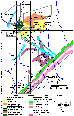
The project area of 780 sqkm was well known to me through earlier work in 1992/93. Orpailleur sites were evaluated by channel sampling, trenching and partly by RAB-drilling. New Au targets
were generated by a combination of geochemical surveys (Au + 33), structural and geological interpretation. Geochemical anomalies with favourable element associations
(i.e. Au-As-Sb, indexes like NUMCHI, CHI, etc.) were given the preference to pure Au-anomalies. The base metal targets were generated by the interpretation of the geological setting, airborne geophysical data and the soil geochemistry data base.
|
|
|
|
|
|
|
|
In total 47 targets were identified, including 40 for Au, 5 for Au and base metals combined and 2 exclusively for base metals. One of the most important discoveries was the delineation of the
so-called Samira Horizon for more than 10 km on the concession area. The Samira Deposit (ca. 2 Mio oz) is currently being developed by the JV of Etruscan-Semafo-Managem on the neighbouring Tiawa Concession. Due to
the re-direction of the programme towards base metals, this discovery could not be followed up.
|
|